Day Trip
Scenic Wonders
Viewsheds and Vantage Points
Grab your binoculars and camera for a byway tour of birds and wildlife that call the Whitefish Chain of Lakes home.
Stop One
Island Lake Woods
Begin on the “spine” of the Byway, CSAH 16, with a visit to Island Lake Woods. This 158-acre mixed forest of red and white pine, spruce, aspen and oak, is located just off CSAH 16. Explore trails and admire the natural beauty of the ridge, wetlands, and towering trees.
Take the Veteran’s Memorial Walking Trail that will lead you over Hay Creek on the north side of the forest. Follow the Ridge Path to the Wetland Walk – a 500 foot boardwalk across the wetland landscape. If you go the entire 500 feet, it’ll take you to the island which has been used by travelers for hundreds of years as a natural look-out area. The island was historically used by Native Americans, as well as Zebulon Pike, a well-traveled, historic explorer.
Stop Two
Uppgaard Wildlife Management Area
Drive 8 miles east on CSAH 16 to this 110-acre haven designed to attract wildlife. Join an interpreted tour on summer Wednesdays or explore independently.
Stop Three
Floating Island on Rush Lake
Head back onto CSAH 16 to catch a quirky sight: Rush Lake’s floating island. This floating, grassy island is a unique feature that appears only part of the year, adding a seasonal surprise to your visit.
Whether you’ll see it or not depends on your luck. The island rises, then sinks continuously throughout the year due to the scientific process of photosynthesis.
Stop Four
Wildlife at Big Pine and Cross Lakes
Head south for great bird watching on Cross Lake, or further south on CSAH 3 at Big Pine Lake where you’ll see Pelican Brook on your left – a little stream that flows out of the Ossawinnamakee Chain and into the Pine River. The brook is one of the few natural spawning areas of the popular bait minnow, the Red-tailed Chub and it was the site of the first minnow seining permit ever issued in Crow Wing County in 1903.
At the circle-drive turn west onto CSAH 11 to view the Osprey nest on the platform high atop the pole. The nest is similar to a Bald Eagle’s nest, with additions made each year. The Osprey feed almost entirely on fish, taking their prey at or just below the surface.
Stop Five
Shaffer Lake and Lowell Wildlife Management Area
Further along, on the south side of the CSAH 11 is Shaffer Lake, a marshland with several floating bogs. It’s a haven for wildlife so have the binoculars ready. After scoping that out, hope back in the car and continue on CSAH 11. Passing through Breezy Point and then turn west at the 4 way stop toward Pequot Lakes. Just west of the new Eagle View Elementary School, turn south onto Nickel Road and stop at the Lowell Wildlife Management Area at Rice Lake, labeled a shallow lake by the DNR and one of the few remaining natural wildlife lakes in the area. It’s home to a variety of fur bearers, waterfowl, and reptiles. The lake provides aquatic habitat for small fish species and is often abundant with wild rice.
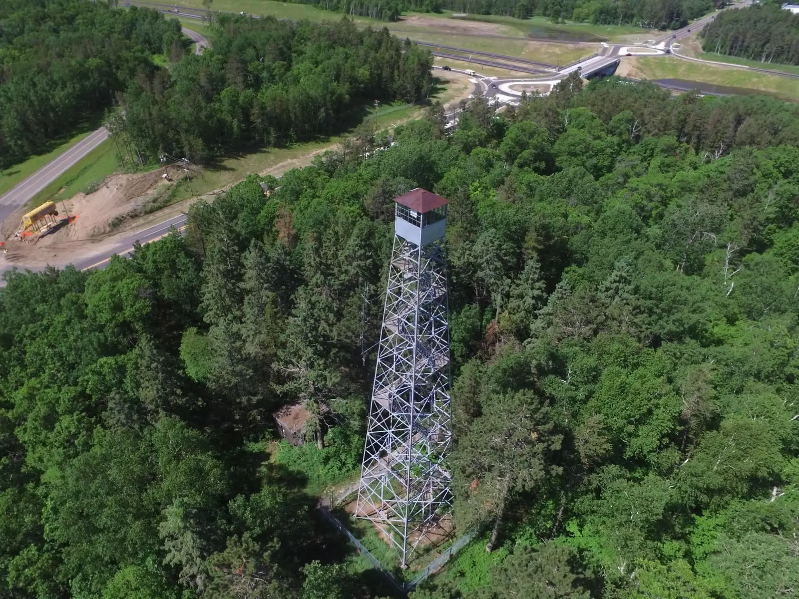
Keeping on CSAH 11, take a climb up our historic 100-foot fire tower at Paul M. Thiede Fire Tower Park. See for miles around Pequot Lakes and enjoy a scenic view in any season, with especially colorful views in the fall. Parking, interpretive signage and excellent trails make this a great choice for people of all abilities.
Bonus Stop
Northern Byway Wildlife Watching
Still full of energy? Drive the northern segment of the Byway, around the north side of the Whitefish Chain where there’s wildlife watching at Ox and Loon lakes on CSAH 66, and some of the best bird watching spots along the meadowland on CSAH 1. East of CSAH 15 about 1/2 mile on the Driftwood Road is the DNR walleye stripping station. During the early spring, walleyes are intercepted here and stripped of eggs as they enter the Pine River to spawn.
Best Byway Views
- Travel South on CSAH 66 – enjoy view of Trout Lake
- Travel on CSAH 16 – between Rush Lake and Cross Lake
- Travel on CSAH 3 – over Pelican Brook
- Travel East on CSAH 11 – to the gates of Breezy Point Resort
- Travel on CSAH 11 – enjoy the view of Historic Fire Tower at Paul M. Thiede Fire Tower Park
- Travel on CSAH 15 – enjoy the view of Rat Lake
- Travel on CSAH 1 – head into Pine River to enjoy the view of Rock Riffle Dam
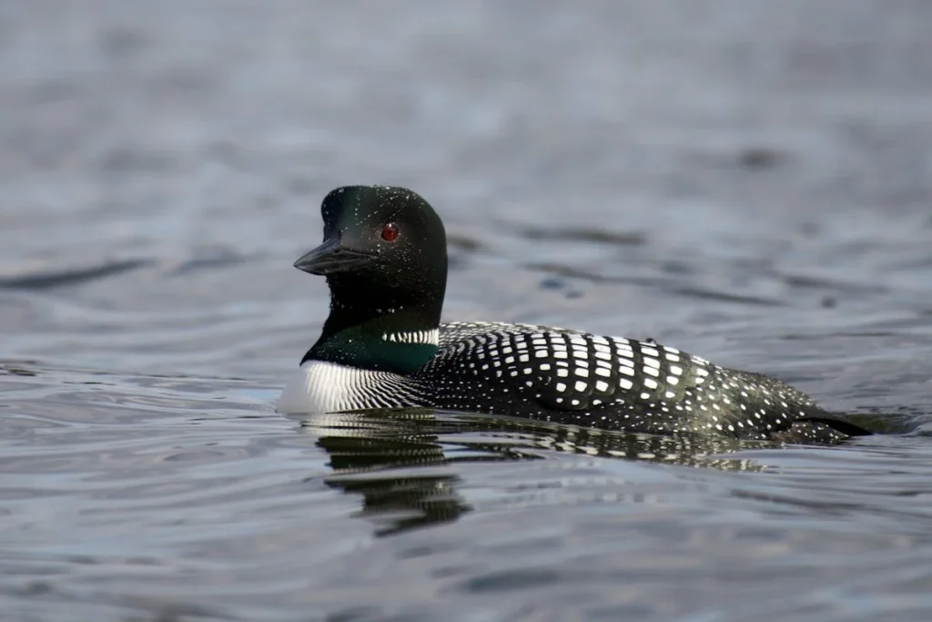
National Loon Center
Love loons? Us too.
Don’t forget to check out the National Loon Center.
Byway Maps
Get a birdseye view of the byway and surrounding areas. Locate interactive kiosks, bike lanes, Paul’s footprints, parks, trails, beaches and more!